Elevating Construction Progress Monitoring
Superior Aerial Imagery, 2D Orthomosaics, 3D Property Models, and Interactive Virtual Tours
All In One Place, Anytime You Need
What We Do
Aerial Still Images / Progression Still Images
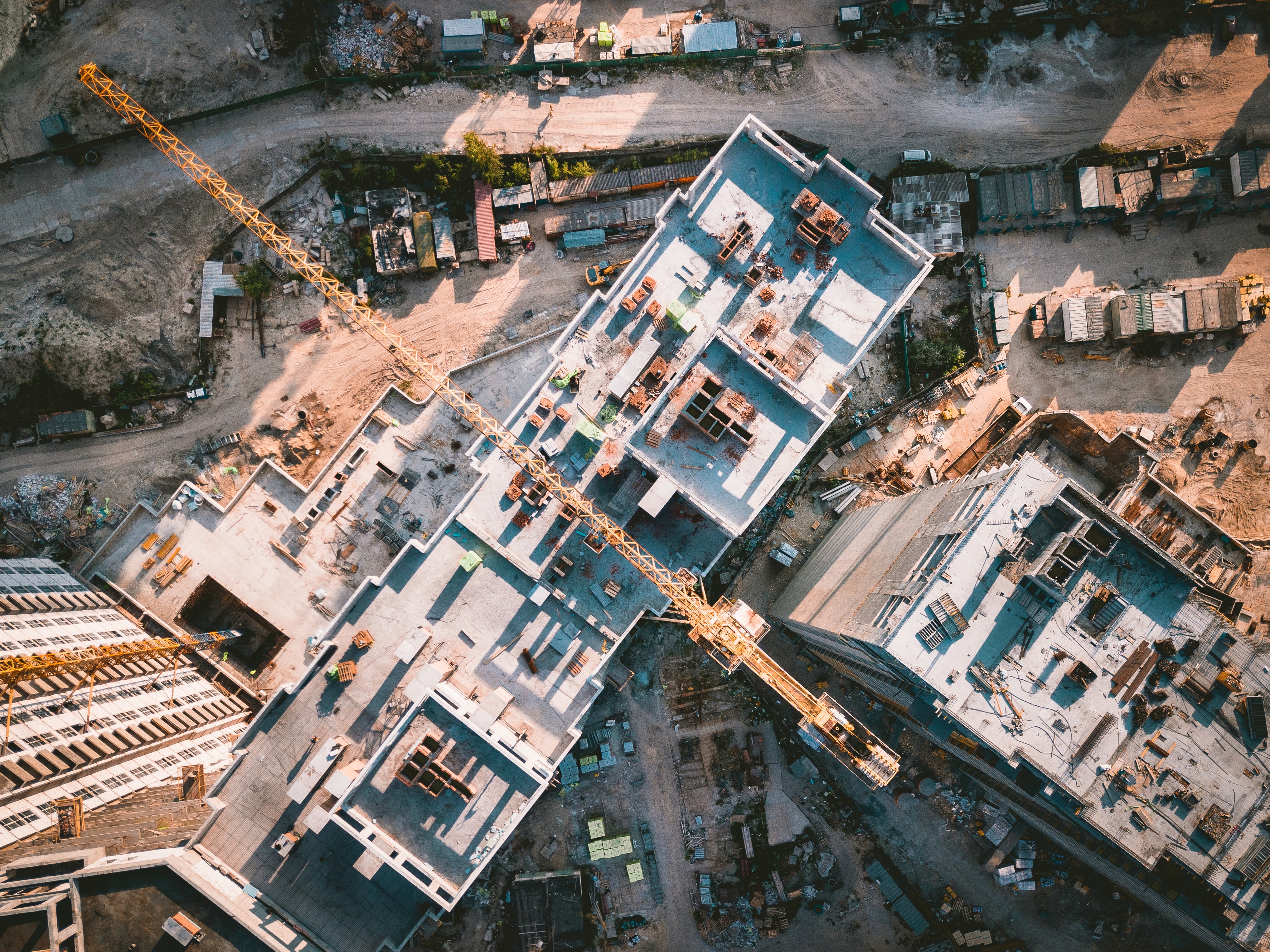
Using advanced drones, we provide high-resolution aerial photos of your construction project. Our progression imaging captures your build's evolution, presenting a clear visual timeline for effortless monitoring and sharing with your team and stakeholders.
Aerial Videography / Progression Videography
Elevate your visual narrative with our aerial videography services, offering high-definition videos of your construction site from multiple perspectives. Document your project's progression in a compelling format with our videography service.
Property 3D Models
Our Property 3D Modeling service uses high-tech drones and sophisticated software to create detailed, interactive 3D models of your construction site, facilitating advanced visualization, and aiding in project planning and presentation.
2D Orthomosaics
With our 2D Orthomosaic services, we offer precision mapping of your construction site. This service provides a detailed, accurate, and scaled aerial view of the site, making it an invaluable tool for surveying, planning, and monitoring construction progress.
Virtual Tour Services for Properties
Experience an immersive journey of your project with our Virtual Tour service, allowing remote exploration with 360-degree views, ideal for reviews, presentations, and marketing.
Empower construction builders with our comprehensive suite of aerial imaging tools designed to streamline project tracking, enhance communication, and boost efficiency. Our cutting-edge aerial imagery services not only provide a complete view of your project anytime, anywhere but also include the creation of highly accurate 3D models of properties at real-life scale. Elevate your project visualization with our advanced technology.
Why Choose Us
-
layers
Diverse Data Formats
We understand that different projects require different views. That’s why we offer a wide range of data formats from high-resolution aerial images, detailed 2D orthomosaics, immersive 3D models, to captivating virtual tours. Whatever your project needs, we’ve got you covered.
-
monitor
Easy Online Viewing
Ease of access is key in today’s digital world. With our services, you can effortlessly view your property’s data formats online. Be it an aerial image, 3D model, or virtual tour, our user-friendly interface makes it simple for you to navigate and explore your project.
-
download
Downloadable Assets
Not only can you view your assets online, but we also offer the option to download them for offline use. Whether you need to present to stakeholders, incorporate them into a report, or use them for marketing, you have the freedom to use these assets as you need, whenever you need them.
-
precision_manufacturing
Innovative Technology
We employ cutting-edge drone technology and sophisticated software to create detailed and accurate aerial imagery. Our dedication to technology ensures you get the highest quality outputs that offer unique and comprehensive perspectives on your construction project.
-
handshake
Customer-Centric Approach
We believe in a customer-centric approach where your needs are our top priority. We work closely with you to understand your specific requirements and deliver tailored solutions that enhance your project planning, tracking, and presentation capabilities.
Choosing us means opting for flexibility, ease of use innovation, and a dedicated partner in your construction journey. Leverage our aerial imagery services to elevate your construction poject management to the next level.
How To Get Started
Our process is straightforward and designed with your convenience in mind. Here are the steps to get started with our services.
Get In Touch
The first step is to get in touch. Fill out the contact form on our website with your contact number, email, and details relating to your project. Alternatively, you can give us a call to provide a brief overview of your project. We're here to listen and understand your needs.
Service Confirmation
Next, we will arrange a meeting with you either in person or via email to discuss your project in more detail. This is the time to confirm the services you need and exclude any you don't require. We'll collaborate with you to tailor a solution that perfectly fits your project's needs.
Scheduling the Flight
Once we have a clear understanding of your project, we'll schedule the flight. Our pilots will visit the property a day in advance to familiarize themselves with the site and prepare for the flight. We will confirm the flight date with you, ensuring it fits within your project timeline.
Data Collection & Processing
Leave the rest to us. We handle everything from this point forward. We'll operate the drone flight, collect the aerial data, and process it into the required formats. Once processed, you will have access to view your assets online. You also have the option to download the assets for offline use.